Canon de Carnue and Carnuel, San Miguel de Laredo Land Grant are the same grant located in Bernalillo County, New Mexico. Manuel Armijo and 18 families made the original petition on February 12, 1763. Governor Tomas Velez Cachupin approved the grant for around 48,000 acres. The U.S. government heard proceedings for this grant before the office of the Surveyor General and the Court of Private Land Claims and reduced the acreage to 2,000 acres.
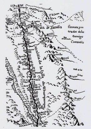
The map below, from 1776, was created by Bernardo Miera y Pacheco, who accompanied the Dominguez and Escalante expedition in 1776. Carnue is correctly positioned, although Chilili is not located correctly – it should be further south, towards Estancia.